
Despite the mosquitoes — always prolific at the Big Gypsum boat ramp towards the end of the boating season in June — the sandstone spires and nearby luscious cottonwood gallery bring a sense of peace. We’re about to embark on a three-day adventure down river in the Dolores River Canyon Wilderness Study Area, an opportunity only possible every three-five years and is dependent on releases from McPhee Dam. 
The Dolores carves through some of the most incredible and biologically diverse landscapes in Colorado and broader Southwest, boasting unique cultural resources, critical wildlife habitat, and world-class recreation. Yet, this distinctive place is threatened by fragmented management, mining speculation, unstructured recreation, and of course, climate change. Because of this, we must preserve and protect the Dolores and surrounding lands as soon as possible.
Currently, there are a few ways to protect the public lands the Dolores flows through. First, is a proposal to create a National Conservation Area in the southern counties the Dolores flows through. Second, is to designate a national monument – the extent of which hinges on the success of the legislation, but could span all five counties in Colorado or just cover the two that are not included in the NCA legislation. Read on to learn more about these proposals and the extraordinary values of the Dolores River Canyon County. __________________________________________________________________________________
With its headwaters in the San Juan Mountains, the river tumbles down a gradual cobblestone corridor, flanked by mountain cottonwood and transitional stone walls, from the volcanic tuff of Lizard Head Pass down into sedimentary red rock cliffs. 
As the valley opens up and the vistas of Sleeping Ute come into view, the Dolores becomes stagnant as it flows into McPhee Reservoir. The fifth largest reservoir in Colorado (fourth if you don’t count Navajo Reservoir, which straddles the Colorado/New Mexico state line) holds water for irrigation and much smaller municipal and industrial uses. Nearly all the water is used in the adjacent San Juan River Basin, so when the water is diverted, none returns to the river. Some water is released from the dam to benefit fish, however on dry years, that amount is shorted alongside farmers with junior water rights and the Ute Mountain Ute Tribe. Overall, the hydrology and channel have changed drastically since the dam was built in the 1980’s.
Protecting this place is popular too, multiple polls across Colorado and in the counties the river flows through, have found overwhelming support for protecting the Dolores River Canyon Country. In a time of political divide, a whopping 70-80 percent of bi-partisan voters polled supported protection.
While legislation or a national monument cannot impact water rights, there is a massive benefit to ensuring the health of the watershed is protected and managed well, since the land and water are interconnected. Further, additional protection and updated management planning can better include and consider Indigenous peoples whose ancestral lands include the Dolores River Canyon Country.
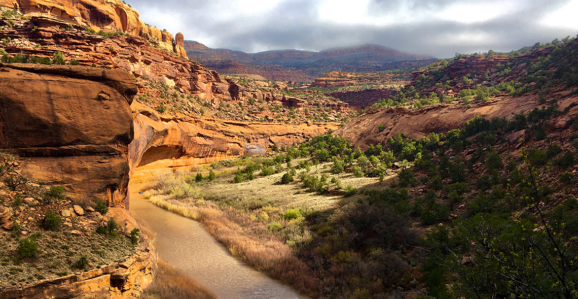
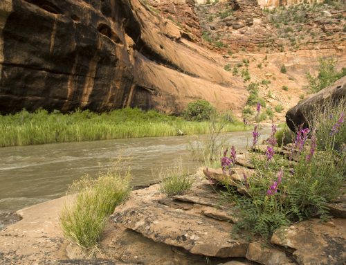
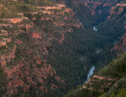
Below the dam, the Dolores flows through the narrow Ponderosa Gorge with scarlet-hued walls and magnificent old-growth Ponderosa Pine trees. In years with phenomenal snowpack, this section is teaming with boaters, prepared to take on either a long day or multi-day trip. But more often than not, wildlife have this remote canyon to themselves. Further down, the river twists north through Pyramid Park and then through the mineral-laden Slick Rock region. Here is where mining interests have begun to stake their claims during the past 150 years, with uranium and vanadium remnants up on the mesas above the river.
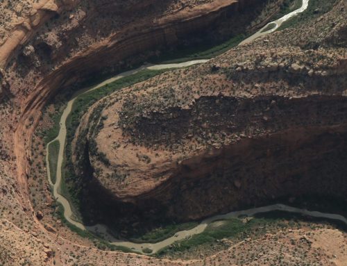
Low mesas and a wide valley border the sluggish river through Big Gypsum Valley, where the river slides through a surprising entrance to the Wilderness Study Area. This is where we started our bug-filled journey into yet another diverse and unique canyon, this one rivaling the walls of every other iconic float in the desert southwest. Big Horn Sheep begin to appear in even greater numbers, and cultural and paleontological sites are hidden among the rocks.
Big Gypsum also marks the northern boundary of the proposed Dolores River National Conservation Area (NCA). Spanning from below McPhee Dam, the proposal spearheaded by Senator Bennet and a local working group would protect 68,000 acres of public lands adjacent to the Dolores River. This legislation was first introduced in Congress 2022, and again in 2023. As this bill makes its way through Congress, we’re hopeful it can become law.
North of the proposed NCA, the rest of the Dolores River Canyon Country does not have a formal proposal to protect it. Yet, the landscape is just as critical to ecology, cultural preservation, recreation and other values as the southern reaches. However, there is an effort that is aiming to get a national monument designated that could span the region outside of the NCA area, or, if Congress cannot pass the legislation, then a monument could protect the entirety of the Dolores River Canyon Country.
A national monument is designated by the President via the Antiquities Act, and they can also be created through an act of congress. Monuments are created to protect “objects” of historic or scientific significance, including cultural resources, ecologically significant areas, or areas that hold important historical values.
The Dolores River Canyon Country to the north includes three unique Wilderness Study Areas, stunning sandstone cliffs, and unique plant assemblages found nowhere else in the country. From Paradox, the stunning valley that the Dolores runs perpendicular to, is framed by the La Sal Mountains to the west—a sense of longstanding cultural significance extremely evident. The connectivity between the riparian corridor and high mountains is critical for big game and vital to conserve.
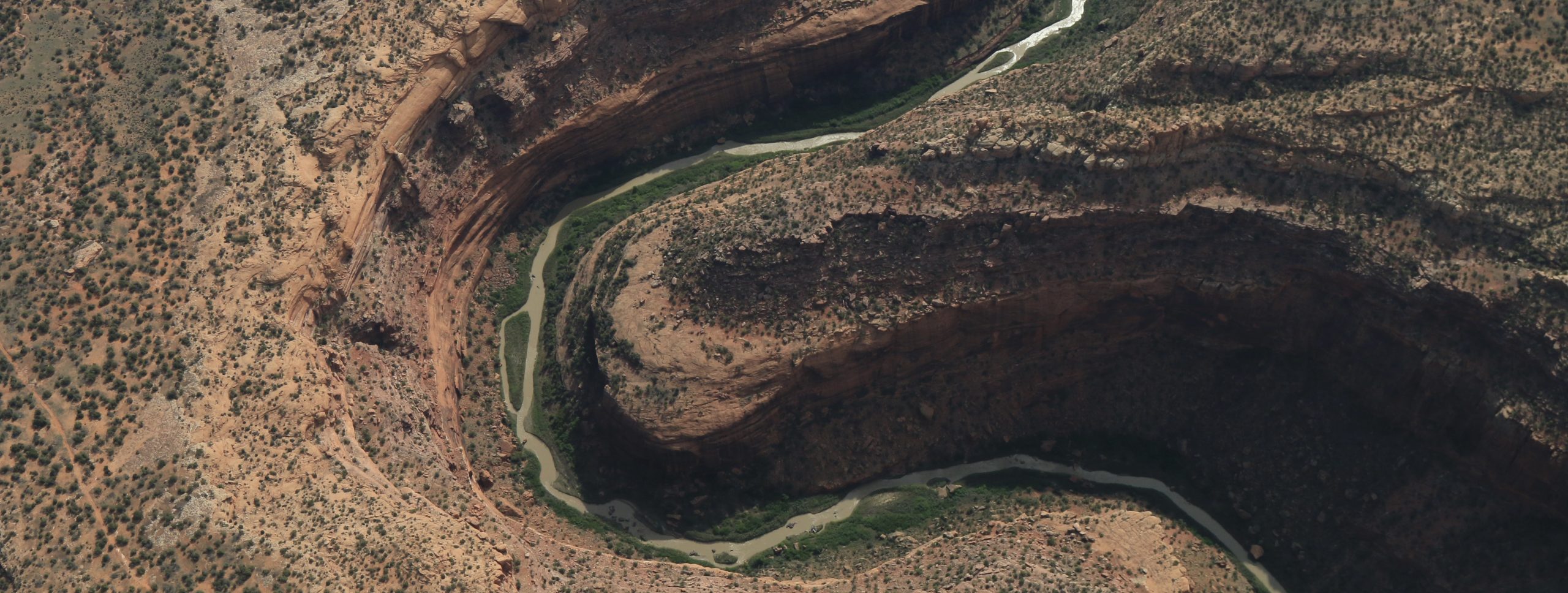
As the San Miguel River meets the Dolores, the river widens and flows past the hanging flume, a historical remnant of gold miners unmet dreams of riches. The biodiversity here is unmatched in Colorado — numerous remote canyons untouched by grazing and other soil disturbing activities.
Before reaching Utah and the Colorado River, the river sweeps through Gateway, Colorado, the sharp redrock fin called the Palisade watching over the small resort community. Up above, the green Uncompahgre Plateau is a lively contrast to the high desert lands below.
These incredible, interconnected lands deserve protection and better management — we need to look back today and do all we can for future generations and that means being a voice for this incredible place.
